

Update 2022: Unfortunately an anti-cruiser campaign driven by a small group of people has managed to convince the population and the mayor to ban sailboats from the lagoon. It is no longer possible to visit the beautiful anchorages around the main island and the motu… Officially sailboats are now only allowed to stop for 72 hours in the anchorage off the main village Rairua.
———————————————————
Raivavae lies about 380 nm SSE of Tahiti, just south of the tropic of capricorn.
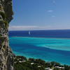
Raivavae is a pretty little island with steep mountains, lush hills that feature a mixture of tropical vegetation and introduced pine trees and numerous banana and taro plantations. It is framed by a narrow, turquoise lagoon and numerous motus. It reminded us of an incredibly quiet and sleepy version of one of the Society Islands with little villages along the coastal road. Despite the assurances of the mayor that there’s lots of tourism going on we saw hardly any visitors apart from the few yachts that stopped by. We spent 3 weeks in April and May 2015 there (mixed weather, lots of NW wind and several lows), came back in November 2017 (1 week of rain without a break) and again in November/December 2018 (3 weeks mostly sunny).
Best time to visit
The Îles Australes are a bit difficult to be included in a cruising itinerary. Southern summer would be the most pleasant time, but unfortunately that’s also the cyclone season and these islands are right in the path of the depressions and cyclones that move down from the Cook Islands or Tahiti particularly whenever the South Pacific Convergence Zone (SPCZ) is very active. In the cyclone season 2014/15 quite a few lows moved by, so we waited in the Gambier Islands until April to sail to Raivavae. Unfortunately that’s already in the cool southern autumn when frequent depressions start moving by in the South, sending high swell and strong winds up. Another option would be November/December, when it’s already warm, but the cyclone season is only in its beginnings.
Shopping and infrastructure
We cleared in at the gendarmerie and gots lots of general information about the island as well as tips for hiking from the friendly gendarme (the only source of touristic information we found on the island, ask him for a copy of the island map!). There’s a post office with an ATM(!) and a mana spot (unfortunately the signal so weak that it only works in the immediate surroundings of the building…). There’s no public water system for potable water and the rubbish disposal also seemed shaky when we were there (apparently the new mayor is trying to change this). You find 2 little shops in Rairua and in every little village around the island (in Anatonu, Vaiuru, next to the airport and at the southern end of the short route traversiere). The shop in Vaiuru sells Diesel (at their pump). In Manahatoa we found a French expat who’s growing lettuce, tomatoes, etc. (ask for Edmond) and he delivered fresh produce for us to the dock (apparently he usually comes by on Fridays). We heard that the baker delivers baguettes all around the island in the morning, but when we tried catching him at his stop in Rairua at the post office at 7 we found that he had already passed half an hour before (of course we only were told after waiting until 8…) and didn’t try any more to buy bread after this disappointing experience.
Hiking and biking
We rented two bikes for a day at the Magasin Louise (Rairua) for 600 CFP each. Biking around the 23 km of coastal road’s a nice way to see the island in a few hours. The road’s mostly concrete, in the south-east partly coral sand with lots of pot holes.
There’s two route traversiere that lead over the ridge of the island from south to north, so you can turn them into round trips by walking back along the coastal road (hitch hiking’s difficult, because there’s very few cars passing). We also hiked up to the ridge of Mt. Hiro, the highest peak of the island. The path starts in Anatonu (just ask for directions when you’re there) and is hard to find in the undergrowth where it starts. Further up the mountain it’s clearly visible. It leads up through the forest and then along some steep cliffs (this part involves some mild rock climbing). After about 1 hour you reach the ridge and the views over the island and the whole lagoon are just gorgeous. The path then goes along the ridge over several minor peaks to Mt. Hiro.
Wildlife
Fishing in the lagoon is very limited due to ciguatera (only a few species are deemed safe by the locals), but despite that we saw hardly any fish. Sadly the coral are mostly dead. On the cliffs of the mountain ridge we saw many red-tailed tropic birds, but just a few noddies and white terns on the motus (even though the vegetation on the motus is rather natural with many endemic shrubs–maybe the locals hunted too many birds/collected eggs in the past).
Charts
When sailing through the pass in the north we found that the Navionics charts had a considerable offset, also CM93-2011 seems to have a small offset. Surprisingly, the Garmin Bluecharts 2008 were our most accurate charts. The pass and the channel to Rairua are clearly marked (even though one of the beacons for the bearing into the pass was missing when we entered). In the rest of the lagoon the charts act more like guidelines, as many shallows and coral heads are not indicated.
Anchorages and navigation in the lagoon
The anchorage off the main village Rairua is well protected in winds from SW to S to E, but has fetch from NE to NW. We anchored about 180 m NW of the dock in 12 m sandy bottom. There are some rocks/coral that may foul your chain.
Raivavae has a very narrow lagoon, but along the northern coast there’s a deep and partly marked channel that we found free of dangers. In southerly winds there’s a convenient anchorage close to Anatonu to hike up Mt. Hiro (it’s right in front of the houses where the path starts).
We anchored in 6 m sand with fenders to buoy the chain around S23° 51.140′ W147° 37.887′ (further in there were a few bommies).
At the eastern cape around Ile Hotuatua it gets a little bit tricky. When going inside the islet you have to pass over a reef-strewn sandbank with about 2-3 m depth. We went outside Ile Hotuatua instead and found a deep (the minimum depth we saw was 5 m), but narrow channel. We passed a ‘gate’ between two shallow coral heads along the following waypoints:
WP1 S23° 51.287′, W147° 36.884′
WP2 S23° 51.350′, W147° 36.825′
The way around the island is deep (minimum 5 m). We had lots of unusual westerly winds and found a protected anchorage right next to the motu with sand bottom between coral heads. We anchored in 5.5 metres next to Ile Hotuatua with a buoyed chain at S23° 51.543′, W147° 36.983′
The southern lagoon is rather shallow (between 5 and 10 m) with lots of steep, small coral heads, so it’s wise to sail at noon with blue skies and a lookout on the bow. At the southern barrier reef there’s an anchorage next to Motu Vaiamanu (Motu Piscine) with its pretty white beaches. We anchored in 6-7 m between many bommies at S23° 52.924′, W147° 37.389′ and used fenders to float our chain (like we always do around coral).
While we stayed in Raivavae a few lows and a front with strong winds from the N and NW passed (sustained winds 30 knots, gusts up to 50) and after sitting the first two out in the apparently safe, but very bouncy anchorage off Rairua, we moved to a little round ‘bay’ (S23° 52.2′, W147° 38.3′) with muddy bottom in 10 m depth in the fringing reef off Vaiuru on the southern coast of Raivavae. We brought out two anchors in a Bahamian mooring to keep the boat from swinging too much as the bay’s only 150 m in diameter. During the northerly blow we had hardly any sustained wind and no waves, but strong gusts from the SE and SW(!) coming in eddies over the mountain.
We did not attempt to sail all around the island, as we were warned about many shallows in murky water off the western cape, but we know boats who went around. The motus on the eastern barrier reef are difficult to access and even more so to anchor, because of murky water and shallow bommies.
If you want to visit motus, it is expected that you ask the owners for permission. We had to ask around a bit, but eventually found the owners of the motus we were interested in.
Our GPS tracks
Photo gallery
Raivavae, Iles Australes
We visited Raivavae in May 2015 during the southern autumn. It was hard to find a weather window to get there and even more so to leave again due to weather quirks (a highly active South-Pacific Convergence Zone led to many lows). Here are some impressions of the few sunny days.
(50 photos)
Donate
If you find our guides useful you might want to buy us a drink when you meet us somewhere around in person or make a donation to our PayPal account.


