

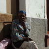
The Cape Verdes are still our favourite islands. We spent 3 months there between October and December 2012, but to see all islands we would have needed even more time. These islands haven’t yet been discovered by mass tourism and enchanted us with their motto “no stress.” A pleasant climate, spectacular landscapes and friendly locals make them a perfect holiday destination. Cruisers find lots of protected anchorages, steady winds for short passages between the islands and even a marina with basic repair facilities.
Unfortunately the official charts are not very detailed, so caution is necessary. Pilot books offer detailed information on anchorages and advise. We used:
- Anne Hammick: The Atlantic Islands, RCC Foundation, Imray, 4. Ed. 2004. Corrections 2010 online at
www.imray.com/corrections/ATLANTIC_ISLANDS_SUPPLEMENT_2010.pdf - André Mégroz und Kai Brossmann: Kapverdische Inseln, www.segeln-kapverden.ch, constantly updated (in German).
- Don M. Street: Street’s Guide to the Cape Verde Islands, Seaworthy Publications, Imray, 1. Ed. 2011.
Each island has its own unique charm. The islands in the east are rather low and dry, the ones in the west green and mountainous. We started with Sal, sailed down south to Boa Vista, further on to Sao Nicolao, Sao Vicente and then down to lovely, little Brava.

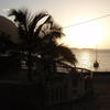
We started our trip with the desert island Sal. It’s a port of entry and even though the brownish sand that dominates the landscape doesn’t seem very attractive at first sight, the friendly locals make it worth a visit. It’s a good place to decelerate and get into the slow, relaxed pace of the Cape Verdes. The anchorage in front of the village Palmeira is protected and has good holding. Further south on the coast it’s possible to anchor in the wide and open bay of Mordeira (beautiful beach, lonely). The anchorages in the south, off Santa Maria are rather open and were quite rolly when we visited.
Boa Vista with it’s white sand dunes is popular wind surfers. The huge bay where the main port Sal Rei is located is usually well protected by the island Ilheu do Sal, but when there’s swell from the north or northwest, the shallow anchorage (yachts anchor in depths between 7 and 3 metres) can become dangerous. It’s advisable to enter the bay from the south (staying away from Englishman’s reef). From there it’s quite a dinghi ride to the village where bars and some shops can be found. There are more anchorages in the south of the island, but we didn’t go there.
When approaching Sao Nicolao from the east, the first anchorage is in front of the little fishing village Carrical, where time seems to stand still. There are no shops, no bars and electricity only on Saturday, but some nice walks lead into the valley and up the mountains (There’s a sandy spot right in front of the black beach in about 15 metres depth, on the left and on the right from that reefs go out, so be careful). On the other side of the huge bay that makes up the southern coast of Sao Nicolao it’s possible to anchor in good conditions in front of the former main port Preguiça. When we were there huge swell made anchoring impossible though. The best anchorage is Tarrafal on the western side of the island. Good holding in about 15 metres, protected from most sides and the friendly town of Tarrafal with shops and restaurants. Sao Nicolao is a hiker’s paradise and the tracks can be reached cheaply by Aluguers (local minibuses).
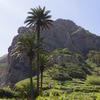
The only marina of the Cape Verdes is located in Mindelho on Sao Vicente (basic repair facilities). The big bay in front of the marina is very well protected. The pleasant town Mindelho offers good markets, bars, restaurants, etc. and the possibility to take a ferry over to Santo Antao, the most spectacular, but also a bit touristy island of the Cape Verdes.
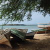
Brava, the smalles island of the Cape Verdes was our favourite. The anchorage in the bay of Faja de Agua is stunningly beautiful (rugged, black cliffs), well protected and calm (the best anchorage is slightly to the right of the church in about 12 metres with a line ashore to keep the bow aligned to the swell). Visiting Brava means travelling back in time. Tiny villages, friendly locals, hiking tracks criss-crossing the island–we stayed an entire month in the same anchorage. From there we started our Atlantic crossing (we got the international clearance already in Mindelho, the immigration officer assured us it would be no problem to visit Brava nevertheless…).
You can find detailed locations of our anchorages along Pitufa’s route on our map, pictures of all the islands we visited in the photo gallery and our first-hand impressions in the blog archive from October to December 2012.
Donate
If you find our guides useful you might want to buy us a drink when you meet us somewhere around in person or make a donation to our PayPal account.

Our Photo Galleries
Cabo Verde: Ilha Brava
Brava's a tiny island, but there is so much to explore and we felt so at home in Faja d'Agua at the westcoast of the island that we spent the whole December anchored in the same bay.
(39 photos)
Cabo Verde: Sao Vicente and Santo Antao
We sailed from Tarrafal, Sao Nicolao to Mindelo, Sao Vicente via Santa Luzia. We visited Santo Antao by ferry. November 2011.
(25 photos)
Cabo Verde: Sao Nicolao
Unspoiled and tourist-free Sao Nicolao enchanted us with its ragged mountains, lush valleys, and friendly people. November 2011.
(50 photos)
Cabo Verde: Sal and Boa Vista
The first two landfalls on our route were the two dry islands of the Cape Verdean windward islands. October 2011.
(23 photos)
Published Articles

Birgit Hackl, Christian Feldbauer: Kapverden — mehr als nur ein Zwischenstopp, OCEAN7 03 (May/June) 2012, p. 16–27. download PDF (in German only)

Birgit Hackl: Cape Verdes — Republica De Cabo Verde, All At Sea Caribbean, January 2013, p. 46–48. Free download from allatsea.net.


