

General
Panama is an incredibly interesting cruising destination. Its many archipelagos and, of course, the Panama canal, attract many cruisers. Even though we stayed almost 7 months, we hardly managed to explore half of Panama’s cruising areas.
Our itinerary:
After sailing down the Caribbean coast of Columbia, we checked-in in Puerto Obaldia in the beginning of September 2012, cruised through the San Blas Islands for about 3 months and then stayed in Portobelo for a few weeks. From there we organized our canal transit and placed several orders for parts to be shipped from the US. We transited the canal in mid-December and stayed a while in Panama City. We explored the Las Perlas for the entire January, sailed back to Panama City in February to collect our deliveries (which also meant quite some work on the boat) before we sailed down the coast and into the rivers of the Darién in March.
Weather
We cruised the San Blas islands during the rainy season, when the trade winds do not reach as far down as Panama. This time was characterized by sunny calms (particularly in the mornings), interrupted by thunderstorms with proper downpours almost daily. In September, some of those thunderstorms were quite violent. According to other cruisers, thunderstorms are frequent the entire summer, while the amount of rain increases towards the months of autumn.
It rained for several days in a row when we were in Portobelo in November…
As soon as we went through the canal in mid-December, we had mostly sunny and dry weather, not only because the rainy season was about to end, but also because the Pacific side is generally drier than the Caribbean side. From January to March the trade winds blow reliably, in the gulf of Panama typically from the north.
Guides
- Eric Bauhaus: The Panama Cruising Guide, 4th Edition, 2010. Available at most marine chandlers in the Caribbean.
- Panama City Cruisers Guide, download from The Southbound Group at Yahoo! groups or ask via pccguide@yahoo.com, regularly updated.
Navigation
Bauhaus provides detailed charts of all cruising areas of Panama in his cruising guide. Some cruisers also have scanned versions of those charts to be used with programs like OpenCPN or MaxSea. The charts are not without errors however. Some reefs are missing or misplaced and shifts are frequent. So don’t use them blindly with your GPS, rather use them to get an idea of the surrounding and eyeball your way through the reefs. See also our specific notes further below. Eyeball navigation requires blue skies and the sun high above or slightly behind. In the rainy season one may need to wait a couple of days in one anchorage to get these good conditions to proceed. Another difficulty is that the waters close to the mainland are often murky, again, particularly in the rainy season.
San Blas Islands
Navigation
The San Blas archipelago is reef-strewn all over, so it’s no wonder that official charts simply don’t cover most of the archipelago at all. Eric Bauhaus made quite an effort to change this. However, his charts are NOT WITHOUT ERRORS!
They are pretty accurate for the western and central archipelago, i.e., west of Tupile, but east of Tupile some reefs are either uncharted or at wrong positions and some islands or even entire charts are displaced. Soundings are frequently wrong.
Here are some of the errors:
We touched a reef in Bahia de Masargandi (SE of Ustupu) at 09°05.214′N 077°52.763′W (according to the chart this is in the middle of the bay entrance at a 15m sounding…).
There is a considerable shift of Isla Mono and the reefs around.
The bank E of Coco Bandero Cays seems to be shifted (instead of the charted 40m gap we found only 8m).
At several occasions we made off-shore routes to avoid narrow and/or shallow inside-reef passages. E.g., from Puerto Escoses to Mulatupu we sailed north along Suledup, Nianega and Soskandup. We also didn’t dare to use the really shallow channel inside of Isla Pinos, but sailed around the island (where we caught a big barracuda). Also from Ustupu to Isla Mono we avoided the inside route along Mamitupu, Achutupu, Islandia and Ailigandi. On the other hand there’s even less an less accurate data in the charts further away from the coast, so these routes aren’t necessarily safer…
Provisioning
The Kuna villages have small tiendas with basic supplies. In most villages bread is baked in one or several houses, due to the lack of signs it takes some asking around to find it though… We fancied the Kuna bread, particularly after all the sweetish bread we had got in Colombia.
Internet
Cruisers use 3G modems and apparently Digicel is the best (only?) provider in Kuna Yala. We found WiFi in Ustupu (at the school) and in Nargana we were even able to surf the internet via the free hotspot right in the anchorage (we have an amplifier antenna).
Panama City
Anchorages
We definitely preferred the “Las Brisas” anchorage (north of the causeway) over “La Playita” (south of the causeway), even though Las Brisas may have some chop when the tradewinds are blowing (which means splashy dinghy rides back to the boat). This chop is still the lesser evil compared to the huge waves the many pilot boats make when racing right through the La Playita anchorage. Also, the tiny Playita marina charges around 35 USD per week to use their dinghy dock. The dinghy dock in Brisas is adventurous (you tie up to a floating dock and then have to pull yourself over to the steps in a rickety little boat), but at least it’s free. VHF channel 74 is used as a hailing channel and is monitored by most of the the cruisers in both anchorages.
Provisioning, Boat Equipment and Spare parts
Panama City is THE place to fill up the boat before sailing out onto the Pacific Ocean. The comprehensive “Panama City Cruisers Guide” is packed with valuable information, e.g., what can be found where in the city. Get the latest version from “The Southbound Group” at Yahoo! Groups (you need to join the group to download the guide).
The marine chandlers in Panama City have lots of fishing gear and power-boat related items, but hardly any sailing-boat specific things, e.g. we didn’t find any blocks… We ordered parts and electronics from the US via Marine Warehouse (marinewarehouse.net), which worked really well. Keep in mind, whatever you try to organize in Panama needs a great deal of patience.
Las Perlas Islands
Navigation
Get used to the tides (tidal range up to 5m at spring tides) and you probably will enjoy them as much as we did. We were fascinated by the constantly changing scenery around the anchorages. Rocks and bridges between islands appear, invite for walks and exploration, and submerge again a few hours later. The tides can also facilitate navigation: approach anchorages on a rising tide so it may lift you soon again after an accidental grounding, even uncharted areas may be safely explored right after low water.
Bauhaus’ charts are pretty good for this archipelago.
Our favourite anchorages
Our clearly favourite spot in the Perlas were the Isletas del Platanal, a wild-life paradise 1 mile S of Viveros. The three little rocks are not marked as an anchorage in Bauhaus’ charts, nor do they show much detail there, but the bay is free of dangers and provides reasonable protection. We anchored at 08°26.546′N 079°00.452′W with plenty of water under the keel in sand/silt with good holding.
Another beautiful anchorage is S of Isla Cañas on the E side of Isla del Rey (Morro Cambombia) with the pretty and friendly village Ensenada close by. Espiritu Santu is also nice and the anchorage always calm. A pretty river invites to be explored by dinghy inland.
Provisioning, Communication, etc.
There are two minimarkets and a petrol station in Contadora. We managed to get fruits and veggies also in the tiny villages on Isla del Rey (Ensenada off Isla Cañas and Esmeralda further down on Isla del Rey. We found the latter rather dirty and unfriendly.).
Mobile phone networks seem to be available only in the northern part of the archipelago (antennas around Contadora and on Viveros). In Contadora we found unencrypted WiFi hotspots.
Darien
Navigation
Bauhaus’ charts of the rivers seem all to be shifted and, as typical for rivers as banks expand or shift, also outdated.
The bank right in the middle of the Golfo de San Miguel around 08°11.64N 078°24.82W is wider and much shallower (4-5m) than indicated on the chart (9-10m). The high swell that often enters the gulf can make this bank dangerous.
Anchorages
Coming from Contadora, we arrived in the gulf late afternoon and stopped at Isla Iguana for one night (rocky ground and uncomfortably choppy in northerly winds because of the long fetch, particularly in wind against current conditions). The next day, on a rising tide, we entered Rio Cucunati, which is deep and the entrance is easy. The anchorages indicated in Bauhaus’ guide are much too shallow for us (our draft is more than 2m), however. We anchored at 08°27.774′N 078°13.472′W and at 08°26.709′N 078°13.173′W with enough water under our keel and good holding, but the river is very wide and therefore choppy when it’s windy. The water’s very salty.
We also anchored somewhat further up the river at 08°31.053′N 078°13.310′W where we visited a family at their finca (farm) on the hills east of the anchorage. We could see quite some deforestation around here.
The entrance of Rio Sucio looks frighteningly shallow on the chart. Luckily the bank did not grow any higher in the meantime, so entering around the middle of the rising tide was no problem. We anchored at 08°29.861′N 078°19.776′W. We liked this river much better: it’s narrower, flora and fauna are more divers. Note there are uncharted gravel banks close to the western shore which dry out at low water.
We visited the traditional indigenous village Caña Blanca by dinghy, which is a couple of miles further up the river.
The village is small but very friendly, the families live on platforms high up, underneath the dogs, chicken, pigs, etc. dwell. We traded some T-shirts for veggies. The village just got road access. So it is very likely that it will loose its authenticity and friendliness in the near future when more tourists will come by.
According to some other cruisers, the villages along Rio Sabana have lost their charm already. People were considered pushy and selling their baskets is a big business. In our opinion this happened mainly because of the road access and the higher number of tourists which come by on bus trips.
South of the Golfo de San Miguel the mountains along the coast are high and spectacular and the bays are beautiful.
We anchored at Bahia Piñas, where the Tropic Star game fishing lodge is located. We were allowed to fill our water jugs at their pier and also to use their WiFi.
In the large but friendly close-by village Puerto Piñas basic provisioning is possible (particularly right after the supply boat was there). Going there by dinghy may be adventurous because of the breakers off the beach caused by the usually high swell entering this side of the bay. It’s easier to ask for a ride on the shuttle boat provided by the lodge for its workers from the village.
Our last stop in Panama was in Ensenada Guayabo and we anchored at 07°24.485′N 078°02.693′W. We used a stern anchor to be better aligned to the incoming swell.
Donate
If you find our guides useful you might want to buy us a drink when you meet us somewhere around in person or make a donation to our PayPal account.

Photo galleries
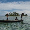
Kuna Yala -- the San Blas Islands
In September and October 2012 we visited the palm-covered islands of Kuna Yala, an autonomous region in Panama, where the Kuna indios live in their traditional villages.
(50 photos)
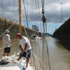
Pitufa's Panama Canal Transit
After our 'holidays' in the San Blas Islands we came to Portobelo to make repairs and to organize our canal transit. The constant rain in November slowed down our progress on these projects and we spent most of our time fighting mold and drying things. On the 15th of December we had our appointment for the Panama Canal transit, despite of our worries everything went perfectly smooth and we arrived happy and relieved on the 'other side' on the 16th of December. Hurray!
(30 photos)
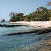
Panama City and Las Perlas
In December 2012 we spent some time in Panama City and sailed to the Perlas with Christians sister Roswitha.
(39 photos)
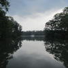
Darién, Panama
In February 2013 we got Pitufa ready for the Pacific in Panama City. We replaced dodgy equipment that had been damaged by a lightning strike in the San Blas, ordered lots of spare parts and filled up Pitufa with provisions. Then we explored the Pacific side of the Darién, its rivers and rainforests in the South of Panama.
(50 photos)
Published articles

Birgit Hackl, Christian Feldbauer: Kuna Yala — Paradies mit Ecken und Kanten, OCEAN7 05 (September/Oktober) 2013, p. 24–29. download PDF (in German only)

Birgit Hackl: Las Perlas — Unspoiled Nature Near Panama City, All At Sea Caribbean, November 2013, p. 36–38. Free download from allatsea.net.

Birgit Hackl: The Darién–In the wake of discoverers and pirates, All At Sea Caribbean, January 2014, p. 80–84. Free download from allatsea.net.
For further information check out our blog entries in the archive from September 2012 to March 2013.


1 comment
Denver Daniel says:
January 11, 2016 at 2:37 pm (UTC 0)
Thanks for the info. We are planning a sail down from Key West this next December.
Cheers,
Dan