

We had little info about Rurutu before we got there, so we had low expectations, but the island was a pleasant surprise for us. It seems it was a volcanic island with a lagoon and a barrier reef before it was raised by 150 m by tectonic movements, so now there are rugged makatea (coral) cliffs along the shore divided by flat coastal regions, long white sandy beaches and volcanic mountains inland–a very pretty mixture.
Moerai harbour and Avera bay anchorage
The harbour on the NE side in the main village Moerai is quite spacious (120 m wide) and deep (5-6 m everywhere), but the entrance is only 20 m wide (watch out for rocks on both sides) and 4.5 m deep. The new supply ship cannot come in, so it is only used by small local fishing boats and occasional yachts. We stayed for 10 days with a bow anchor and 2 long stern lines to the quay, bow facing the entrance. We were only the third boat(!) of the year (end of October 2018). The harbour is perfectly calm in any wind direction but E (it gets bouncy) and NE. The entrance is open to the NE and in strong winds from that direction (or east) the harbour becomes dangerous–make sure to leave before you get trapped.
Before the wind shifted from E to NE we moved to Avera bay on the western side: Looking down at this bay from the mountains the week before we thought it was impossible to anchor there (in SW swell over 3 m there was incredible surf breaking all over the bay), but when we arrived the swell was down to 1.5 and it was rather calm. We anchored on a big sandy patch in 14 m depth just outside the boatpass. Later on the wind picked up to 30 kn from the ESE, gusting 50, and it got somewhat rolly and bouncy.
Moerai is a port of entry. Even when arriving from within French Polynesia, the gendarmes expect you to report. The gendarmerie building is at the southern end of Moerai.
Provisioning, shopping, infrastructure
Moerai has a surprisingly well-developed infrastructure, there are well-stocked supermarkets, a post office and a bank both with ATMs(!), a petrol station, a hospital and a daily veg and fruit market just next to the little harbour. Coffee is locally grown and roasted, the little ‘Manureva’ factory at the northern end of Moerai gives tours and sells the freshly ground product (cheaper than the supermarkets).
The snack just opposite the harbour is open for lunch on weekdays and the restaurant Tiare Hinano (a few streets north of the harbour) offers Chinese and Polynesian dishes every day but Monday (lunch and dinner).
There are 2 car rental places in town (at the petrol station and Sinn supermarket) with daily rates of about 10.000 CFP. First we planned to rent a car, but hitch-hiking is so easy that we didn’t bother getting our own vehicle in the end. Soon everyone on the island seemed to know that we were the ‘sailboat people’ and they took us directly to the dock without even asking. Even the gendarmerie car gave us a ride once ![]()
The other two villages (Avera and Hauti) have both a small supermarket and Avera has a little snack open for lunch.
The supply ship comes every 2 weeks and 4 to 5 flights a week connect Rurutu with Tahiti.
Activities and attractions
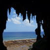
The road around the island is 36 km long and it’s dotted with look-outs from steep cliffs and caves that were once coral and are now covered in stalactites and stalagmites. There is just little tourism on Rurutu so the sights have no signs, but friendly locals directed us to all of them. Not many yachties make it here, so people are genuinely interested and hospitable. Hitching rides we found that every car stops for a raised thumb and the locals usually set us off right at the beginning of the trail to the cave/hiking trail we searched. We only had a rather sketchy map, but we found most sights and stumbling over a cathedral-like grotto hidden in the forest or cliffs makes you feel like real discoverers ![]()
The interior of the island is criss-crossed with trails and dirt tracks and you can spend days walking along the ridges and up the peaks.
From July to October humpback whales are the biggest tourist attraction in this area and we saw many whales all around the island on a daily basis.
Sights and walks
These are just suggestions to explore, get lost and stumble over sights all around Rurutu–like we did ![]() Good luck finding your way! If you don’t enjoy adventurous exploring as much as we do there are many locals guides willing to show you around.
Good luck finding your way! If you don’t enjoy adventurous exploring as much as we do there are many locals guides willing to show you around.
Area around Moerai
Ana Taneuapoto:
This cave is just a short walk on the main road south from Moerai. A short path leads up to the cave from the road, just before the lookout at Pointe Arei. We walked a bit further, just after pension Manotel (No. 6 on the map), then took a dirtroad up the plateau and returned in a loop to Moerai (2h round trip + cave).
Grotte D’Otare:
Just north of Moerai are some spectacular cliffs with a lookout. We searched for the marked ‘Grotte,’ but only found a chasm in the makatea cliffs in the forest (take the trail left before the road goes up to the lookout).
Belvedere aux Tava’e:
Walking from the town center past the mairie, a dirt road leads up towards the ‘Belvedere’ lookout. We stayed on the dirtroad (it passes two creeks) and then we were lucky just following the basic direction the map indicates (there are a few crossings along the way). Up on the mountain there’s a fork in the road: the main trail goes up the plateau, another trail goes down (maybe to a house or garden) and a few metres before that fork another less cleared dirt road goes to the right steeply up the hill–that’s the one you want. It leads up to an antenna and from there a tiny trail leads over the makatea to a belvedere overlooking the village of Moerai and the cliffs (Grotte Otare) (2 h including some getting lost).
NW side
Ana Aeo is the only cave with a proper sign… It’s just a few minutes walk from the main road.
Behind the pension Teautamatea lies the well-cleared marae (stones from a former temple platform) Tararoa in their garden. Eline, the owner (she’s British and married to a local) is a great source for info about history, local insights, etc.
Area around Avera
Ana Puuru:
A spectacular cave at the end of a beautiful beach walk: Walk north from Avera along the road, then down to the beach before the road climbs up towards the lookout. Keep walking along the beach (sometimes it’s better to stay further up and climb over boulders to keep dry feet) until you reach the cliffs. It takes some rock climbing to reach the cave high up–bring a torch it goes far in (2 h return, 3 with lots of photos). This walk is only possible at low tide when the SW swell is low.
Trou de souffleur and Ana Tupapa’u:
Hitch a ride from Avera up the mountains, past a lookout to Narui. A dirt road leads to a few houses down at the beach–the trou du souffleur is a gap in the reef where the waves break. We were there when the SW swell was high (2-3m) but did not see much of a blow hole… Walk along the white beach northwards until you reach the cliffs. We found small caves up in the rocks, but we’re not sure if that was already Ana Tupapa’u, but it was a spectacular walk with incredible views. Maybe it takes some rock climbing from there and/or low tide and no swell to find a bigger cave. Or you might start from the Avera side and walk southwards.
Area around Auti
Ana Mou’o:
Walk from the beach in Auti northwards–there’s a trail starting at the picnic area, or you can just walk along the beach (maybe the prettier option) and later climb up to that trail on the coral rocks (just a few meters up from the beach). Where the cliffs start you have to go up on the trail. Follow the path until you reach a big and spectacular cave. Local guides say it’s possible to continue on from there to the next cave (Ana Taupe’e), but that would involve rock climbing. We gave up in our sandals and walked to that cave from the other side (see below).
Ana Taupe’e:
Where the road from Auti northwards comes down from the mountains there’s a little creek in a curve before the road reaches the beach. Right in that curve there’s a little bridge (just some rusted metal tubes with a few rotten planks on top) that goes to an abandoned house. Hop over that bridge (carefully) and walk along the creek. Before you reach the beach, a trail starts to your right up the hill. You reach a deep cave after a few minutes.
Hikes inland
Manureva and north:
The pass of the road between Moerai and Avera is a convenient starting point because there’s quite some traffic, so it’s easy to hitch up. The three highest peaks lie conveniently along one caldera and the trail starts on the ridge off the road from Moerai to Avera. We hiked Mt. Manureva, Taatioe and Teape within 2 hours (they are all between 360 and 390 m high). Just below Ana o Ina (according to locals a small and hidden cave) is located, but we couldn’t find it. If you don’t return the same way but try to make it down the coast (like we did), be prepared to face a maze of dirt roads (not just the ones on the map, but many more, some of them dead ends that lead to gardens and not further ![]() . We tried to find our way towards the W coast and eventually got there–maybe it’s wiser to stay on the main path that leads to the Plateau Tetuanui and then down to Moerai (5 h, some getting lost included).
. We tried to find our way towards the W coast and eventually got there–maybe it’s wiser to stay on the main path that leads to the Plateau Tetuanui and then down to Moerai (5 h, some getting lost included).
Pito and south:
Also on the pass between Avera and Moerai the dirt road towards Mt. Pito starts (just on the other side). We walked along the ridge (down south the hills are less steep and not so spectacular, it’s easy walking) to Mt. Pito and on to Mt. Erai and Taurama. After Taurama a smaller dirt road goes off the main road and down towards Auti. From there you could hitch a ride back to Auti and Avera or walk on to the…
Gauffre Puorotini:
Walk a few metres further south until you reach 3 terraces (it looks like 3 houses will be built there in the future). From the lowest terrace a dirt road leads into the bush. Follow the main road, there are a few crossings, we just walked into the direction our incomplete map suggested… At some point a smaller dirt road goes off to the right (parallel to the coast), take that one and walk until it turns into a foothpath. The foothpath leads to a maze of high makatea rocks you have to cross without a visible path (just a few minutes, be careful to lay out some markers to find the way back!!) until you reach the edge of the cliff and a viewpoint over the coast and the sea far below.
Weather
If it wasn’t for the weather Rurutu would be perfect. Unfortunately the Australs are very unlucky weatherwise: not only does it get seriously cold in winter but a convergence zone moves over the islands every 7-10 days and brings bad weather (troughs, lows and nasty fronts). According to climate charts (see below) December to March are the rainiest months. In October we had nights with only 17°-18° Celsius and during the day temperatures rose to 22°-24°. In summer (Dec.-Apr.) the convergence zone becomes fairly stationary over the Australs and there’s a certain risk of tropical depressions and cyclones.

Climate chart (click for larger image)

Map of Rurutu (click for larger image)
Our Photo Gallery of Rurutu
Rurutu, Austral Islands
Spectacular cliffs and caves, beautiful beaches, mountain hiking, migrating humpback whales, and super friendly people--Rurutu has it all! We spent 3 fabulous weeks there in October 2018.
(72 photos)
Donate
If you find our guides useful you might want to buy us a drink when you meet us somewhere around in person or make a donation to our PayPal account.


