

Tubuai is a high island with two volcanic mountain chains and a lagoon around that can be easily entered through the wide, clearly marked pass in the NW. We spent two weeks there in November 2018. Yachties are expected to check in at the Gendarmerie even when arriving from another island in French Polynesia (just like everywhere in the Austral Islands).
Anchoring and navigation
Most cruising guides only mention one anchorage east of the main village Mataura on the northern side of the lagoon that can be reached in a marked channel, the rest of the lagoon is mostly uncharted and rather shallow.
On the chart a little dent in the fringing reef just opposite the pass looked like it might give protection in easterly winds, so we tried to anchor there at S 23°21.04′ W 149° 30.267′ right after we arrived, but even though it was a calm day (light easterly winds, small SW swell) somehow the swell wrapped around the island, built up coming through the pass area and we were rolling miserably. The basin further in with a small dock proved too shallow for our 2.1 m draft.
We moved on to the village, but found that the outer reef on the northern side is so deeply submerged, that ocean swell (even if it comes from the SW) makes it almost unhindered into the lagoon. We anchored first behind the breakwater (S 23° 20.53′ W 149° 28.55′) for better protection from chop in E-NE winds, but rolled badly as the swell makes it all the way in. We then moved past the dock and anchored at S 23° 20.34′ W 149° 28.18′, but found it just as uncomfortable.
We used a sunny day to explore the lagoon westwards from the pass, left the charted area and carefully searched for a navigable channel around the northwestern cape of the island where the airport is. We utilized satellite images for this kind of exploration, however, it turned out that several areas that looked like coral on the images were just sand overgrown with algae. The trickiest and shallowest bit was just in the beginning: at S 23° 21.00′ W 149° 30.54′ we had to zigzag our way around some shallow banks and bommies, followed by a generally rather shallow stretch around S 23° 21.38′ W 149° 31.28′ (depths around 3 – 4 m), but then the channel got deeper around the airport (6 – 9 m) and we anchored south of the airport at S 23° 22.54′ W 149° 31.74′ (about 5 m depth, in places only a thin layer of sand over coral plates with medium holding). This anchorage is wonderfully protected in wind directions from SE via E to NE and we sat out a strong southeasterly there without any rolling.
Provisioning
Tubuai is a big, fertile island with lots of agriculture. Stands along the road sell locally grown lettuce, cabbage, tomatoes, cucumbers, etc., but even carrots and potatoes grow in the temperate climate. There is a medium-sized supermarket in the main village and many little ‘snacks’ sell lunch. The pharmacy (the only one in the Australs and Gambiers) is located near the harbor east of the main village.
Activities
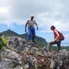
A well-maintained path leads up the highest mountain Taitaa. It is easiest to start at the route traversiere (the road that crosses the island N-S) and walk on a forest road up the ridge eastwards. A foot trail brings you the last bit up the highest peak which features fantastic views. Then you can descend on the other side down a very steep path that reaches the coast near the college (east of the dock). In November a marathon event takes place on Tubuai (the ‘Lychee raid’) and the routes are marked with red arrows that remain all year round and are very helpful when hiking without a guide.

Climate chart for Tubuai (click for larger image)
Photos from our visit
Tubuai, Austral Islands
In October 2018 we visited Tubuai. We took a while to find a cozy anchorage, but then we enjoyed the hiking and the friendly people.
(24 photos)
Donate
If you find our guides useful you might want to buy us a drink when you meet us somewhere around in person or make a donation to our PayPal account.


