When we left Cagliari on Sardinia, we were not quite sure where we would sail next. We considered the Balearic Islands and the mainland of Spain. Also, we were not fully provisioned for a longer passage because we had to wait out the Mistral that was blowing with up to 40 kn while at anchor in Cagliari with the dinghi already deflated and tied down on deck. So we started the passage without much stock of fruits, veggies and fresh bread on Wednesday, Aug. 10th (however, we had lots of cans etc. on board so we always managed to cook fancy dinners…).
For the first three days, the wind was either highly variable, very light, or not there at all. Not even the blister was of much help. So we had to use the engine a lot. From Friday, Aug. 12th, evening on, however, we got relatively constant, favorable easterly winds.
This allowed convenient sailing, most of the time we sailed dead-downwind, wing and wing.
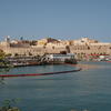
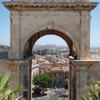
After being becalmed so often we couldn’t let this opportunity for fair winds pass, and the prospect of visiting another touristy place like Mallorca or Southern Spain didn’t seem very appealing anyway. So we continued towards Gibraltar. After noticing that the Spanish exclave Melilla was on our way, we spontaneously decided on a stop in Africa. Today in the morning, after 670 nm and 8 days at sea we reached Melilla, a Spanish exclave in Morocco.
We’re glad to get some rest after the many nightwatches, but Leeloo doesn’t fancy marinas with their strange people and noise. She prefers sailing passages when she can be sure that everything around is free of potentially dangerous persons (to her that means everybody except us). By now she’s grown accustomed to life on board again, has found her sealegs and is no longer afraid of high waves.
Like usually when we let the wind decide on destinations it seems we have been lucky choosing Melilla. Our first marina after Pula is really cheap (6 Euros a day compared to 140 on the Liparian islands…) and Melilla is an interesting town. We’ll explore the historic centre tonight and in the following days letting the wind decide when the journey will go on.